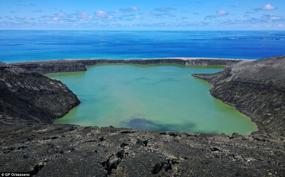
Beautiful images have emerged of a new island that has formed off the coast of Tonga - although scientists say it could soon disappear.
The photographs were taken by three men who climbed to the peak of the land mass 40 miles (65 km) northwest of the capital, Nuku'alofa.
The island started forming in January after a volcano exploded underwater and then expanded creating a mile long, cone-shaped formation.
Hotel owner GP Orbassano, along with a friend and his son, arrived at one of the island's three black beaches on Saturday.
'It was a perfect day, with fantastic views – bright blue sky and the sea was the same colour as the sky,' GP Orbassano, one of the locals, told Tonga's Matangi Online.
The island is made mainly of scoria, which is a dark coloured volcanic rock that can sometimes contain crystals.
The holes in the material form when gases that were dissolved in the magma come out of solution as it erupts
Scientists believe the dimensions of the new island are about 1.1 miles (1.8 km) by 0.9 miles (1.5km), and that it rises about 328ft (100 metres) above the sea.
Orbassano admitted that the climb was dangerous as a result of the excessive heat on the dark landscape, according to Matangi Online.
However, he said the natural beauty of the location could make it into a popular tourist attraction before the island disappears in a few months.
The island was first spotted in an image taken by the Pleiades satellite on 19 January 2015.
The Hunga Tonga-Hunga Ha'apai underwater volcano, that created the formation, is located between two land masses in the Tonga archipelago - Hunga Tonga and Hunga Ha'apai.
They said the surface of the island was still warm and, after climbing to the highest point of its crater, they caught sight of a vast green lake which smelled of sulphur.
'The island is double the size of Fafa. There is a lot of rock, it's not just ash. It looks like the moon,' said Orbassano.
The region is dubbed Ring of Fire because of the high levels of seismic activity in the area.
Hunga Tonga's latest eruption began on 19 December 2014 and continued into this month.
Steam, ash and nitrogen and phosphorus erupted from the ocean, and international flights around the island were cancelled.
At its peak, the ash plume reached heights of more than 14,765ft (4,500 metres).
In addition to creating the new island, the eruption is also said to have stripped its two neighbouring islands of vegetation, and caused what is known as a red tide.
A red tide, or algal bloom, occurs when there is a sudden increase in the amount of algae in water.
When levels of nitrogen and phosphorus rise, which can be caused by underwater eruptions such as the one off the coast of Tonga, algae can multiply.
Typically, this causes water to turn green, but the effect also causes reds and yellows to be released. In particular, a bloom of dinoflagellate algae causes water to turn blood red in colour.
Land masses forming after volcanic eruptions and earthquakes are relatively common.
In 2013, a volcanic island appeared off the coast of Japan, near the uninhabited island of Nishino Shima.
Dubbed Niijima, it was first spotted on 20 November in the Ogasawara chain around 600 miles south of Tokyo and had tripled in size by the following month.
(dailymail.co.uk)
ANN.Az


Follow us !


